


WASHINGTON — (CNN) A container ship whose crew includes 28 Americans is missing near the eye of Hurricane Joaquin as the sprawling storm readies to send possibly historic flooding to the U.S. East Coast this weekend.
The ship El Faro, carrying the 28 U.S. citizens and five others, was still missing Friday near the Bahamas after the U.S.-flagged ship sent a distress signal a day earlier to the U.S. Coast Guard, the agency said Friday.
A C-130 airplane searched for the vessel Friday morning, but was unable to make contact, said Coast Guard Capt. Mark Fedor.
Joaquin rumbled Friday in the central Bahamas as a Category 4 hurricane with 130 mph winds.
Perhaps the only good news is that the hurricane is not expected to directly touch the U.S. mainland as it marches northerly.
Still, Joaquin threatens historic floods in the Carolinas and other inundations to the Southeast and Mid-Atlantic.
The Southeast could see up to 20 inches of rain, with South Carolina bearing the brunt of flooding, CNN meteorologists say.
The flooding scenario will develop Friday night through the weekend. Meanwhile, flash flood watches extend from Atlanta to near New York City.
Joaquin is projected to travel over the open sea, far offshore, but the long distance won’t stop it from sending waves reaching 20 feet, high winds, and widespread coastal flooding.
Ship goes missing
The El Faro apparently became caught in Joaquin, authorities say.
A U.S. Coast Guard plane was “searching for missing 737′ container ship w/ crew of 33 near eye of #Hurricane #Joaquin,” the guard said Friday on Twitter.
The 735-foot-long cargo ship was bound for San Juan, Puerto Rico, from Jacksonville, Florida, authorities said.
At time of its departure on Tuesday, the ship’s officers were monitoring what was then Tropical Storm Joaquin, said Tim Nolan, president of TOTE Maritime Puerto Rico, which owns the vessel.
But on Thursday at 7:20 a.m. Eastern, the firm lost all communication with the El Faro, Nolan said.
“There are a number of possible reasons for the loss of communications among them the increasing severity of Hurricane Joaquin,” Nolan said in a statement.
The Coast Guard received a report Thursday morning that the ship had lost propulsion and was taking on water, but that the flooding had been contained.
The ship was reported to be in distress somewhere near Crooked Island in the Bahamas.
Two Air Force C-130 planes were deployed in Thursday’s unsuccessful search.
The path of Joaquin
Early Friday, Joaquin essentially stalled over the Bahamas for a second morning. It began moving northward later in the day, the Hurricane Center said.
The latest tracking maps show the powerful Category 4 storm staying well offshore after it leaves the island chain, which is expected to happen sometime on late Friday or early Saturday morning.
What’s not going away is the rain for the already waterlogged region.
Moisture from Joaquin is being pumped into a weather system stalled along the coast.
“We’re looking at historic flooding in coastal South Carolina,” said CNN meteorologist Rachel Aissen. Ten to 15 inches of rain are expected.
Charleston, South Carolina, will be especially hard hit, but heavy rain will penetrate all the way inland to Columbia, more than 100 miles away.
Gov. Nikki Haley declared a state of emergency in anticipation of major flooding.
Friday night football games were moved up a day over flooding concerns in the state’s Lowcountry region. Others were postponed.
Not just South Carolina
Flood advisories and warnings stretch from North Florida to Connecticut and as far west as parts of West Virginia, Kentucky and Tennessee.
The governors of New Jersey, North Carolina and Virginia joined South Carolina in issuing their own states of emergency.
“I don’t think we’re going to see wind impact,” CNN Meteorologist Chad Myers said, “but we’re going to see flooding impact. We have all of this tropical moisture, and it’s going to get sucked into the Carolinas, into Virginia, maybe even into Georgia, and that will cause flooding.”
The Appalachian Mountains could get soaked because of the interaction between Joaquin and a low-pressure system over the southeastern United States, according to Myers.
The moisture created from those two systems could then flow down from rivers into cities, creating the potential for significant flooding in some areas.
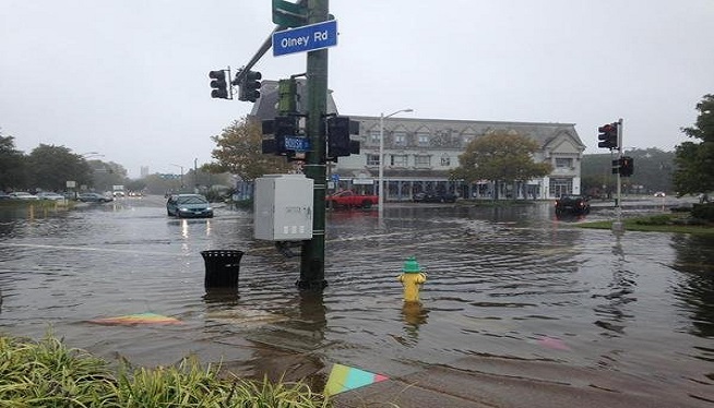
Along Virginia Beach’s Atlantic Avenue, a main thoroughfare about two blocks from the ocean, business owners appeared to be taking a wait-and-see approach.
There were no boarded-up windows. Stores remained open, but there were only a few customers.
Beach towns in October can be that way.
There was no panic at the Sunsations beach shop.
“We’re usually fine here,” said Sharlotte Castillo, “maybe a little rain, but we’re staying open.”
Even as far north as Waterbury, Vermont, Skip Flanders was keeping an eye out. He’s seen firsthand from 2011’s Hurricane Irene that the heavy rains from a huge tropical system like this can have devastating effects far from the coast.
“We had 28 inches of water in our house from Irene,” Flanders told CNN affiliate WCAX. “I certainly hope that something of that proportion doesn’t happen again.”
Battering the Bahamas
The storm’s “extremely dangerous conditions” are expected to continue over portions of the Bahamas on Friday, according to the National Hurricane Center.
Extensive flooding was reported, with up to 3 feet of standing water in some areas. Winds are 130 mph. Rainfall is expected to be about 12-18 inches over the central Bahamas, but some areas could see as much as 25 inches, the Hurricane Center said.
“We are closely monitoring Nassau now to see where the storm is at first light … since that is where the majority of the population is located,” said Basil Dean of the Bahamas Department of Meteorology. “Freeport, Grand Bahama, Eleuthera and other tourist areas are also being closely monitored.”
The-CNN-Wire ™ & © 2015 Cable News Network, Inc., a Time Warner Company. All rights reserved.
(Photo: CNN)


